Auction 83 - Part I - Rare and Important Items
November 23, 2021
Displaying 1 - 2 of 2


Auction 83 - Part I - Rare and Important Items
November 23, 2021
Opening: $1,200
Estimate: $2,000 - $3,000
Sold for: $1,500
Including buyer's premium
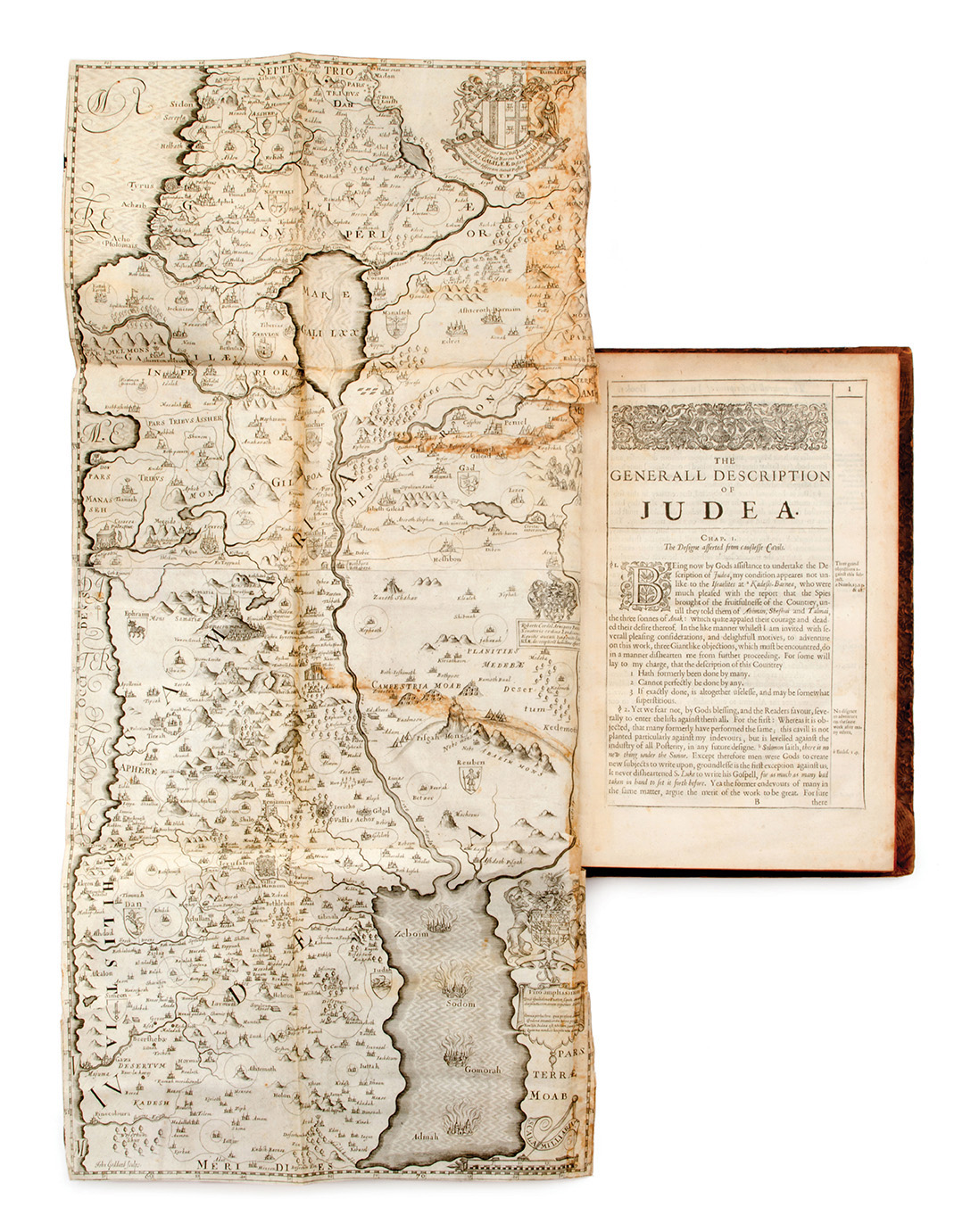
A Pisgah-sight of Palestine and the Confines thereof, with the History of the Old and New Testament acted thereon, by Thomas Fuller. Printed by J.F for John Williams, London, 1650. English with some Latin.
Comprehensive study on the subject of Palestine and its history in accordance with the Bible and New Testament, by Thomas Fuller (1608-1661), English churchman, historian and author.
The book features 30 engraved plates (most of them double) including an engraved title page and a frontispiece illustrating the heraldic emblems of aristocratic families; large map, folded, of the Holy Land; a map of Jerusalem and maps charting the territorial boundaries of the Twelve Tribes of Israel; plates with plans and illustrations portraying the Temple in Jerusalem; and more.
Fuller based his work on maps by Christian van Adrichem, adding numerous illustrations and decorations of his own. The maps are adorned with the heraldic emblems of aristocratic families, and bear dedications to patrons and philanthropists who assisted Fuller in publishing the book.
[8], 434 (more than 434; mispagination), [1], 202, [17] pp. 30 engraved plates. (most engraved plates. included in pagination), 33.5 cm. Good condition. Stains. Minor blemishes. Stains and tears to map of Holy Land. Tears, incl. open tears, to several additional engravings (mended with paper). New binding, with parts of original binding laid down; blemished (with tears and abrasions).
Category
Palestine – Maps and Travelogues
Catalogue


Auction 83 - Part I - Rare and Important Items
November 23, 2021
Opening: $1,800
Estimate: $2,000 - $3,000
Sold for: $4,000
Including buyer's premium
Eight volumes of the first edition of publications of the Palestine Exploration Fund (PEF) survey of Western Palestine headed by Claude Conder and Horatio Kitchener, and a special edition of the survey map, marked with sites mentioned in the Bible, the Apocrypha, and the works of Flavius Josephus. London: The Committee of the Palestine Exploration Fund, 1881-88. English, with some Arabic, Hebrew, and additional languages.
The Survey of Western Palestine was conducted between the years 1872 and 1877 by teams of researchers, surveyors, and British army personnel, all belonging to the Palestine Exploration Fund (PEF), who completed – for the first time in the history of Palestine – a survey of virtually every acre of the land, from end to end, using modern surveying techniques. The survey enabled the publication of the Palestine Exploration Fund map (1880), one of the most important maps in the cartographic history of Palestine, regarded as the "mother of all modern maps" of the country, followed by the publication of an extensive series of volumes of studies documenting and detailing the finds and discoveries of the survey. These publications include three volumes listing each and every settlement, river, architectural structure, or hill identified by the surveyors; a single volume devoted to Jerusalem; a detailed survey of the fauna and flora; a comprehensive listing that includes thousands of place names in Arabic; and more. Most of the volumes also include numerous illustrations, maps, drawings, and plans (either on separate plates or in-text); some of these were colored by hand.
The present set includes eight volumes of the first edition, containing numerous plates and illustrations, some of them colored by hand. Seven volumes bear labels indicating "special edition"; these labels give the copy number – 234 – of the set, and are personally signed by James Glaisher, head of the PEF's executive committee. In addition to the eight volumes, this lot also includes a copy of the special edition of the survey map.
1-3. Memoirs of the Topography, Orography, Hydrography, and Archaeology, by C.R. Conder and H.H. Kitchener. Three volumes. Vol. I – Galilee: x, 420 pp. + [30] plates (one folding); Vol. II – Samaria: [1], vii, 455 pp. + [22] plates; Vol. III – Judaea: vii, 450 pp. + [21] plates.
4. Arabic and English Name Lists, listing thousands of Arabic names for places and sites, and Arabic inscriptions, along with transcriptions into English and explanatory comments by E.H. Palmer. 1881. [1], v, 438 pp.
5. Special Papers on Topography, Archaeology, Manners and Customs, Etc., by Charles Wilson and other authors. 1881. vii, [1], 362 pp.
6. Jerusalem, by Charles Warren and C.R. Conder. Volume devoted to a survey of Jerusalem. 1884. vii [i.e. ix], 542 pp. + [10] plates (one plate missing).
7. The Fauna and Flora of Palestine, by Henry Baker Tristram. Volume devoted to a survey of the fauna and flora. 1884. xxii, 455 pp. + xx pls (13 of them colored by hand).
8. A General Index, by H.C. Stewardson. 1888. [2], 164, [2] pp.
Eight volumes, approx. 28 cm. Condition varies.
Enclosed: An additional volume of PEF publications, from the second edition (this particular volume is missing from the present set): Memoir on the geology of Arabia Petrae, Palestine and adjoining districts, by Edward Hull. 1889.
9. Biblical edition of the survey map: Map of Western Palestine, from surveys conducted for the Committee of the Palestine Exploration Fund … Special edition, illustrating the Old Testament, Apocrypha, and Josephus. London: Stanford's Geographical Establishment, 1882.
The survey map, marked with sites mentioned in the Bible and Apocrypha, and in the writings of Flavius Josephus.
Large map: Approx. 158X95 (divided into 30 separate sections), laid down on canvas, folded, and housed in original slipcase. Good condition. Minor stains. Blemishes to slipcase.
Category
Palestine – Maps and Travelogues
Catalogue